

Route 3 Access Improvements
Route 3 is being evaluated to make it easier and safer for people to get from sidewalks to busA rubber-tired transit vehicle designed for roadway operation to transport a large number of persons for public transportation service. In most cases, it operates with a self- contained source of motive power. More stops, including opportunities to add crosswalk signals for better connections within the community. The study identifies six general focus areas, each selected based on location and including several potential strategies. A summary of these areas is provided below:
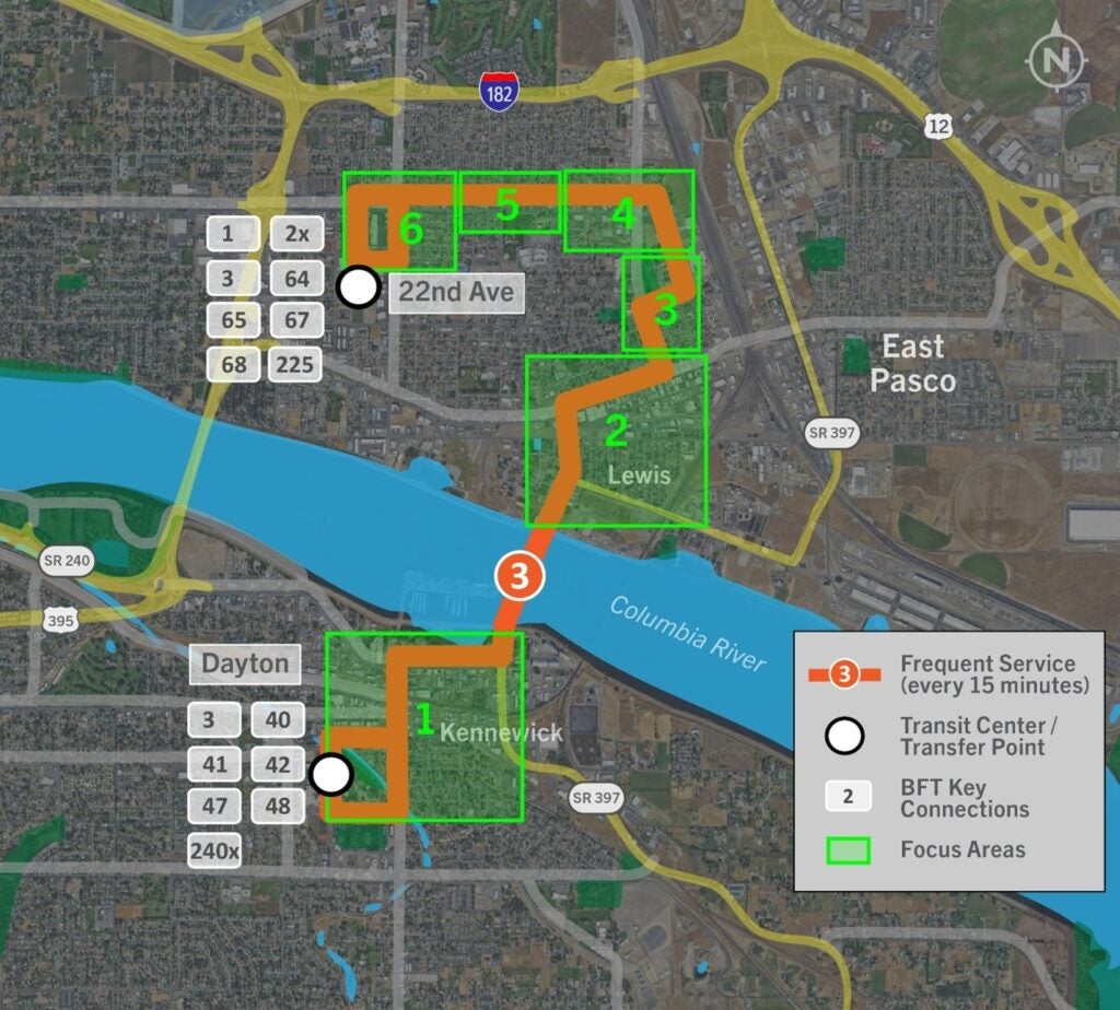
Route 3 Focus Areas:
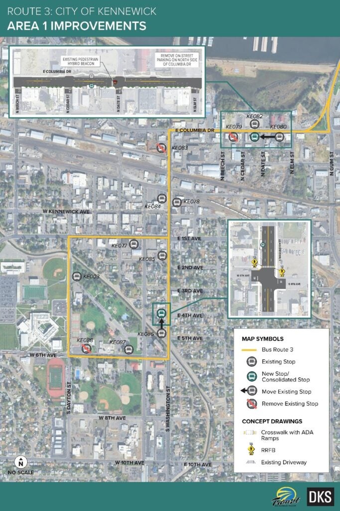
- Area 1 – Kennewick
- Area 2 – Downtown Pasco
- Area 3 – City Hall, 1st Avenue (Pasco)
- Area 4 – 1st Avenue, Court St (Pasco)
- Area 5 – Court St, 5th Ave to 17th Ave (Pasco)
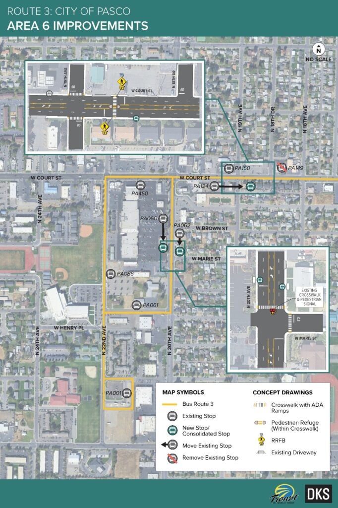
- Area 6 – 20th Ave, 22nd Ave Transit CenterA facility where transit vehicles converge, enabling passengers to transfer among routes and services. Transit centers are generally located off the street and provide passengers with a shaded or enclosed waiting area, seats, drinking fountains, and transit information. More (Pasco)
These areas are being reviewed to enhance safety and accessibilityThe extent to which facilities accommodate persons with disabilities, including wheelchair users. More. In some locations, changes are suggested due to the history of vehicle and pedestrian accidents. In others, the focus is on making travel routes more comfortable and convenient, such as adding improved sidewalks or safer crossings. All of the ideas presented here are still under consideration and will only be implemented once stakeholders agree.
The Route 3 Focus Areas are detailed below with information about the proposed improvements for each area.
Area 1 – Kennewick Map including reference to consolidation of stops KE079 and KE080, sidewalk widening and crosswalks on Columbia Drive between Beech Street and Elm Street, installing a RRFB at Washington Street and 4th Avenue, and consolidating stops KE087 and KE088.
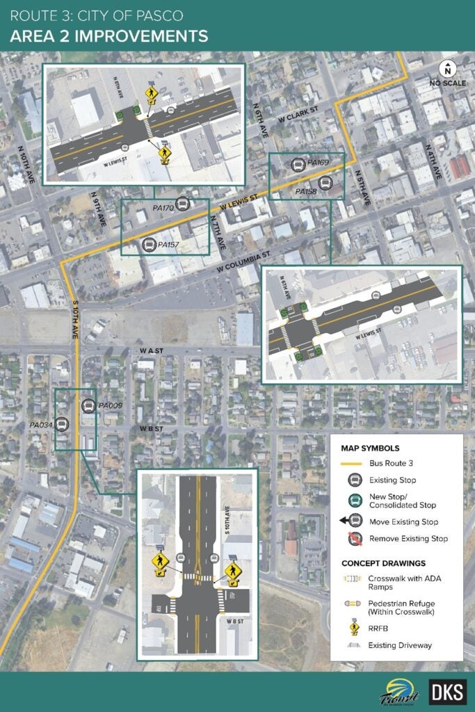
Area 2 – Downtown Pasco Map including reference to widening sidewalks along 10th Avenue and installing a RRFB near B Street, building curb bulb-outs and RRFB on Lewis Street near 8th Avenue, and installing busA rubber-tired transit vehicle designed for roadway operation to transport a large number of persons for public transportation service. In most cases, it operates with a self- contained source of motive power. More bulb-outs and crosswalks on Lewis Street at 6th Avenue.
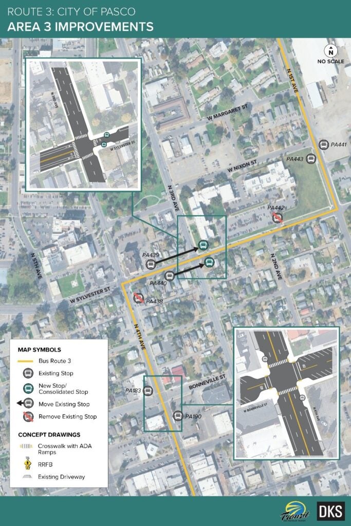
Area 3 – City Hall / 1st Avenue (Pasco) Map including reference to curb bulb-outs and busA rubber-tired transit vehicle designed for roadway operation to transport a large number of persons for public transportation service. In most cases, it operates with a self- contained source of motive power. More bulb-outs on 4th Avenue at Bonneville St, consolidating stops by relocating to the east side of 3rd Avenue and Sylvester Street, and adding curb and busA rubber-tired transit vehicle designed for roadway operation to transport a large number of persons for public transportation service. In most cases, it operates with a self- contained source of motive power. More bulb-outs.
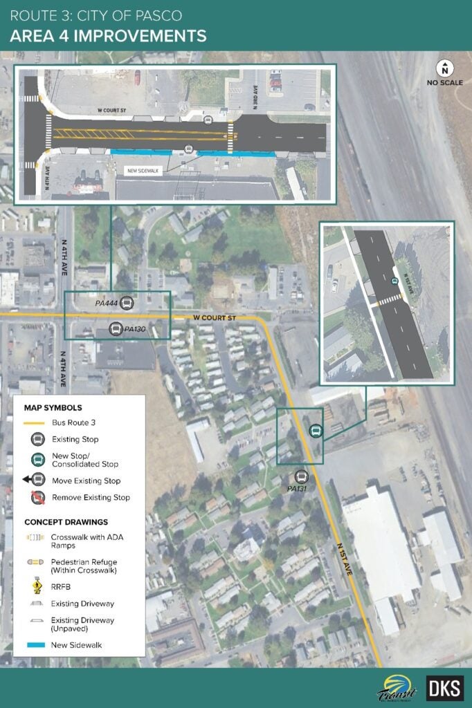
Area 4 – Court Street (Pasco) Map including reference to installing a busA rubber-tired transit vehicle designed for roadway operation to transport a large number of persons for public transportation service. In most cases, it operates with a self- contained source of motive power. More pullout pad and station on the east side of 1st Avenue near PA131, and installing a marked crosswalk across Court Street at 3rd Avenue and connecting sidewalk on the south side of Court Street east of 4th Avenue.
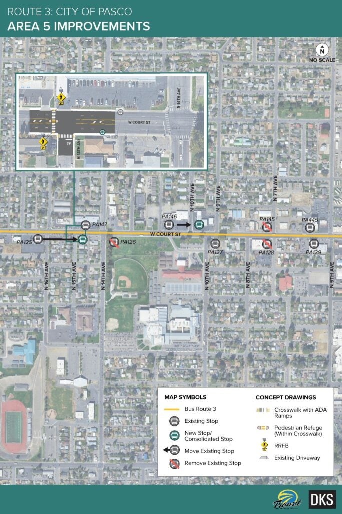
Area 5 – Court Street (Pasco) Map including reference to stop consolidations, potential agreement to move PA146 on Court Street east of 10th Avenue, and installing a RRFB and pedestrian refuge island at 15th Avenue, and installing marked crosswalks on side streets at 9th, 10th, 12th, 13th, 15th, 16th, and 17th Avenues.
Area 6 – 20th Avenue / 22nd Avenue Transit CenterA facility where transit vehicles converge, enabling passengers to transfer among routes and services. Transit centers are generally located off the street and provide passengers with a shaded or enclosed waiting area, seats, drinking fountains, and transit information. More (Pasco) Map including reference to stop consolidation, installing a RRFB and pedestrian refuge island in Court Street between 18th Avenue and 19th Avenue, installing marked crosswalks to the north and south legs of 19th Avenue at Court Street, and moving stops PA060 and PA062 to the north side of Marie Street.